
AmericanRivers.org/rio-grande river
Because river systems are so critical to human thriving and commerce it makes sense to focus on protecting and nurturing those systems to guarantee our children will enjoy their benefits. Toward this end I think John Wesley Powell had a great idea when he advocated for western state lines to be drawn along river drainage basin boundary lines.
See, John Wesley Powell’s Report on the Lands of the Arid Regions of the United States (1878)
It’s too late for that, still, the importance of clean healthy rivers to downstream stakeholders, remains as crucial as ever. Especially as water levels drop.
Alberta Park sits below the Great Divide mountain slopes of the Wolf Creek snowshed, located within the Rio Grande National Forest. Its meltwater feeds through Alberta Park on the way to the Rio Grande River, and that gets way too little attention in this controversy were it sometimes feels like legalities and tossing papers at each other is the only thing that matters.
This posting is dedicated to the Rio Grande River and is basically a collection of articles, a bibliographic resource for learning some important background.
Alberta Park at Wolf Creek needs advocates to start lobbying the USDA-USFS powers-that-be to begin making every effort possible to reconsider going forward with this 1980’s speculative luxury retreat. Why? This is 2024, not the go-go ‘80s, environmentally and sociologically (read stakeholders) - the realities of the Rio Grande River Basin have become way more challenging.
I’m no expert, but I do know enough to seek out experts and get my facts from them. That’s what this bibliographic collection is all about, sharing important information with the friends of Wolf Creek & Alberta Park.
We The People should be able to expect the USDA-USFS to start incorporating the Rio Grande River and the greater good, along with science and climate realities. It’s time to get serious about prioritizing the health of the Rio Grande River system, as paramount over some developer’s glory pipe dream.
~~~~~~~~~~~~~~~~~~~~~~~~~~~~~~~~~~~~~~~~~~~~~~~~~~~~~~~~~~~~~~~~~~~~~~~~~~
GETTING TO KNOW THE RIO GRANDE RIVER
Texas Water Resources Institute - by Kerry Halladay - email - 2024
HYDROLOGY OF THE WOLF CREEK PASS AREA
MountainStudies.org - Dr. November 7, 2014 - Project Leader: Mark Williams (University of Colorado)
A RIVER STRETCH BEYOND ITS MEANS
Wild Earth guardians.org - email - 2024
A DRYING RIVER - The Rio Grande is in peril, and the consequences have already manifested
Erick S. Albarran - medium.com - Environmental Issue Profiles 2021
CLIMATE-SMART CONSERVATION ALONG THE RIO GRANDE RIVER
Janessa Price - WorldWildlife.org -
Rio Grande International Study Center -
THE RIO GRANDE WATERSHED IS AT ITS ECOLOGICAL BREAKING POINT.
By: Rio Grande Waterkeeper - March 21, 2019
Protecting forests and water in northern New Mexico.
Pennsylvania State University - e-education course
RESTORING THE NATURAL FLOW OF THE RIO GRANDE-RIO BRAVO RIVER
Daniel Vernick, December 07, 2023 - Worldwildlife.org
THE RIO GRANDE ISN’T JUST A BORDER - IT’S A CRISIS!
By Vianey Rueda & Drew Gronewold - October 23, 2023 - The Conversation Media Group
CLIMATE-SMART CONSERVATION ALONG THE RIO GRANDE
World Wild Life Fund - Janessa Price - 2024
RIO GRANDE, A DRYING RIVER
Erick S. Albarran - March 21, 2021 - medium.com
THE RIO GRANDE RIVER - InTeGrate
Interdisciplinary Teaching about Earth for a Sustainable Future
Water Matter - THE RIO GRANDE AS AN INTERNATIONAL RIVER
By Margaret J. Vick, J.S.D. (2012) - Utton Transboundary Resources Center - University of New Mexico
PUBLIC REPORTS FROM WOLF CREEK SUMMIT above Alberta Park, Colorado
Air & Water Database Public Reports
CLIMATE OF THE SOUTHWEST UNITED STATES
~~~~~~~~~~~~~~~~~~~~~~~~~~~~~~~~~~~~~~
~~~~~~~~~~~~~~~~~~~~~~~~~~~~~~~~~~~~~~
GETTING TO KNOW THE RIO GRANDE RIVER
More than the sum of its pieces
Texas Water Resources Institute - by Kerry Halladay - email - 2024
… Sandoval is not alone in describing the river as unwell. Several U.S. and international nonprofit groups including American Rivers, the World Wildlife Fund and the World Resources Institute place the Rio Grande on “endangered river” lists due in large part to high levels of water stress in the region. The river’s water is overallocated, with its flow frequently low to nonexistent in places. For example, 2001 was the first time in a half century that the river stopped flowing to the Gulf of Mexico. …
Rosario Sanchez, Ph.D.: “Whatever we do will impact the entire river up and down stream and people both north and south of the border.”
A river in pieces: A resource to be used
The river is an intimate part of an ever-growing number of lives. Currently, an estimated 12-13 million people on both sides of the border depend upon the Rio Grande/Rio Bravo for their water, according to the International Boundary and Water Commission (IBWC). … (Link)
How The Rio Grande Came to be.
A unique history has brought us to an environmental reckoning today
~~~~~~~~~~~~~~~~~~~~~~~~~~~~~~~~~~~~~~
HYDROLOGY OF THE WOLF CREEK PASS AREA
Dr. November 7, 2014 - Project Leader: Mark Williams (University of Colorado)
Administered by the Mountain Studies Institute
The Wolf Creek Pass area is a unique environment that has been formed by abundant precipitation, high elevation, and steep mountain slopes. These characteristics have formed extensive wetland areas. A private land owner has proposed to build a large development in this area.
The hydrology of the Pass Creek Watershed, located adjacent to the Wolf Creek Ski Area, was investigated to better understand the environmental impacts of future large-scale development of this watershed. …
… These results suggest that the source of water for wetlands and springs in the area of the Alberta basin is groundwater rather than new snowmelt runoff. Recharge appears to be snowmelt up gradient of the wetlands complex. Residence time appears to be on the order of 1-5 years. Construction of impervious areas of about 50% in the development area, along with removal of snow for road access and other activities, will likely result in a severe reduction in infiltration. The decrease in infiltration may result in a reduction in groundwater recharge that feeds the wetlands complex.
Therefore there is reason to believe that development up-gradient of the wetlands could have down-gradient impacts by affecting the hydrologic and ecological processes supporting these wetlands. Development may:
Reduce infiltration through the addition of impervious surfaces: (a) roads, (b) driveways, (c) buildings
Disrupt ground water flow paths that support the wetlands through (a) construction of basements, (b) burying utilities to depths of 10’ or greater, (c) road cuts
Drainage systems installed to divert water away from roads and buildings.
~~~~~~~~~~~~~~~~~~~~~~~~~~~~~~~~~~~~~~
A River Stretched Beyond Its Means
Wild Earth guardians.org - email - 2024
The third-longest river in the United States, the Rio Grande is vital to the history of the desert southwest. It is, literally and figuratively, the lifeblood of the region. Like any living thing, the Rio has a pulse. When that pulse dies, those who depend on the Rio as an ecological, cultural, and economic engine suffer.
The Rio’s pulse is dwindling for a variety of reasons. People take more water from the river than the river has to give, something that archaic water law continues to allow. Dams and other infrastructure, meant to stretch water supplies further, inhibit the river’s snowmelt-driven spring flows. And climate change spells disaster for the Rio and those who depend on it. … (Link)
Rio Grande River facts – a Western icon and the lifeblood of the desert Southwest
~~~~~~~~~~~~~~~~~~~~~~~~~~~~~~~~~~~~~~
A Drying River
The Rio Grande is in peril, and the consequences have already manifested
Erick S. Albarran - medium.com - Environmental Issue Profiles 2021
The Rio Grande ranks as the fourth longest river in the United States, the fifth longest in North America, and the twentieth longest in the world at 1,885 miles. This truly massive body of water begins atop the snowy San Juan mountain range of the Colorado Rockies, flows down through New Mexico, and traverses the southern edge of Texas before ultimately emptying into the Gulf of Mexico (Dillworth).
According to the International Boundary & Water Commission (IBWC), “the entire Rio Grande/ Rio Bravo watershed covers an area approximately 924,300 square kilometers (335,000 square miles), with approximately half the watershed in the United States and the other half in Mexico.”
It serves as a natural border between three American states and between the countries of Mexico and the U.S.. For hundreds of years, the people of the Rio Grande Basin have depended on the river as a precious life source. … (Link)
~~~~~~~~~~~~~~~~~~~~~~~~~~~~~~~~~~~~~~
Climate-smart conservation along the Rio Grande
Janessa Price - WorldWildlife.org -
The Rio Grande-Rio Bravo is the lifeblood of the water scarce Chihuahuan desert region. The river and its tributaries serve as the primary source of water for some 6 million people, and provide food and shelter to a number of plant and animal species. But, climate change, coupled with rising populations and diversifying demands, threatens the river’s future and the future of those who rely on it. To increase the resiliency of the river and all who depend on it, WWF and local partners are restoring crucial ecosystems. This includes transforming bare riparian areas, which were cleared decades ago for mining and construction activities, into thriving habitats full of local vegetation. … (Link)
~~~~~~~~~~~~~~~~~~~~~~~~~~~~~~~~~~~~~~
RIO GRANDE IN HIGH DEMAND
Will Rogers once described the Rio Grande as “the only river I know of that is in need of irrigating,” a prescient observation considering how fragmented this fabled river has become. At nearly 1,900 miles, the Rio Grande is runner-up only to the combined Missouri-Mississippi system in length within the continental U.S. Or it would be, if it still flowed the length of its channel. … (Link)
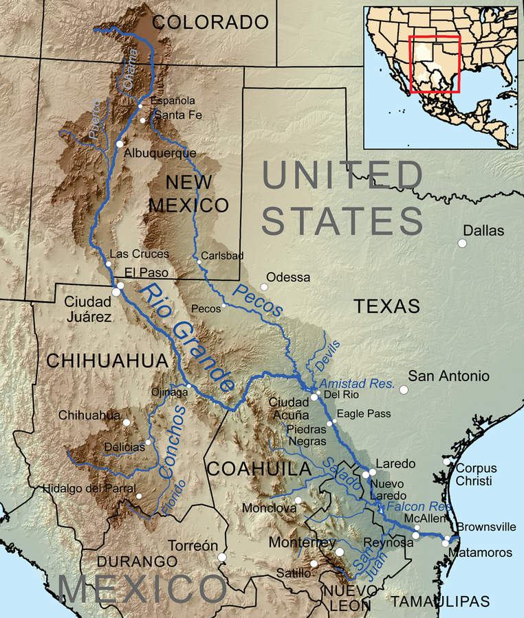
Image #1 Map of Rio Grande - https://www.americanrivers.org/wp-content/uploads/2022/12/map-rio-grande-river.png
~~~~~~~~~~~~~~~~~~~~~~~~~~~~~~~~~~~~~~
About the Rio Grande River
Rio Grande International Study Center -
The river basin covers 355,500 square miles – across three U.S. states and five Mexican states – and encompasses a diverse range of eco-systems, climates, geology, hydrology, cultures and traditions. In the United States, it flows through Colorado, New Mexico and Texas. In Mexico, the basin spans across Durango, Chihuahua, Coahuila, Nuevo Leon and Tamaulipas.
The river serves as a critical wildlife corridor, and is home to a wide diversity of plants and vegetation. … (Link)
~~~~~~~~~~~~~~~~~~~~~~~~~~~~~~~~~~~~~~
The Rio Grande Watershed is at its Ecological Breaking Point.
By: Rio Grande Waterkeeper - March 21, 2019
… The stakes are high: The Rio Grande provides irrigation and drinking water for more than 6 million people. And the river relies on every last drop of water that meanders its way from precipitation-fed streams, wetlands, and groundwater through the basin to its mother river and, ultimately, the sea. These waterways crisscross the landscape like blood vessels, a vast hydrologic circulatory system that determines the health of the river itself. … (Link)
~~~~~~~~~~~~~~~~~~~~~~~~~~~~~~~~~~~~~~
Rio Grande Water Fund
Protecting forests and water in northern New Mexico.
January 22, 2023
New Mexico’s Rio Grande and its tributaries supply water for wildlife and one million people. The health of these waterways is key to the health of Albuquerque, Santa Fe, Native American Pueblos and other communities—half of New Mexico's population—and an essential ingredient for our state’s economic growth.
The Rio Grande Water Fund protects forests and boosts local economies by creating jobs and wood for products. The project is also generating a sustainable source of funding for a 20-year program to restore 600,000 acres of forests in northern New Mexico and southwestern Colorado. … (Link)
~~~~~~~~~~~~~~~~~~~~~~~~~~~~~~~~~~~~~~
The Rio Grande River water
Pennsylvania State University - e-education course
Rio Grande River water is in demand because of the intense agriculture in New Mexico-Texas (Fig. 8) as well as in northern Mexico. This water supply deficit has been exacerbated by prolonged drought in the southwest. Figure 9 is a long-term record of flow of the Rio Grande River (at Otowi Bridge) reconstructed by tree ring records calibrated to more modern flows (see TreeFlow). Note the frequent cycles of surfeit and drought, and the most recent steadily decreasing flow trend beginning about 1990. … (Link)
~~~~~~~~~~~~~~~~~~~~~~~~~~~~~~~~~~~~~~
Restoring the natural flow of the Rio Grande-Rio Bravo River
Daniel Vernick, December 07, 2023 - Worldwildlife.org
New study shows how river restoration could save important species while supporting farmers
… For the first time, a study supported by WWF analyzed the full river basin, exploring the impacts of restoring different amounts of natural flow, along with how to make it happen. The research team built a first-ever hydrologic model of the entire basin to show how much the natural river flows have been altered throughout the river’s length. The model was then used to identify how and where the water is being consumed and to design strategies that could allow more water to be left in the river. … (Link)
~~~~~~~~~~~~~~~~~~~~~~~~~~~~~~~~~~~~~~
The Rio Grande isn’t just a border – it’s a river in crisis
By Vianey Rueda Drew Gronewold
October 23, 2023 - The Conversation Media Group
A hidden water crisis
For nearly 80 years, the U.S. and Mexico have managed and distributed water from the Colorado River and the Lower Rio Grande – from Fort Quitman, Texas, to the Gulf of Mexico – under the 1944 Water Treaty, signed by presidents Franklin D. Roosevelt and Manuel Avila Camacho. The Colorado River was the central focus of treaty negotiations because officials believed the Colorado basin would have more economic activity and population growth, so it would need more water. In fact, however, the Rio Grande basin has also seen significant growth.
For the Rio Grande, the treaty allocates specific shares of water to the U.S. and Mexico from both the river’s main stem and its tributaries in Texas and Mexico. Delivery of water from six Mexican tributaries has become the source of contention. One-third of this flow is allocated to the U.S., and must total some 76 million cubic feet (2.2 million cubic meters) over each five-year period.
The treaty allows …
~~~~~~~~~~~~~~~~~~~~~~~~~~~~~~~~~~~~~~
Climate-smart conservation along the Rio Grande
Janessa Price - 2024
The Rio Grande-Rio Bravo is the lifeblood of the water scarce Chihuahuan desert region. The river and its tributaries serve as the primary source of water for some 6 million people, and provide food and shelter to a number of plant and animal species. But, climate change, coupled with rising populations and diversifying demands, threatens the river’s future and the future of those who rely on it. To increase the resiliency of the river and all who depend on it, WWF and local partners are restoring crucial ecosystems. This includes transforming bare riparian areas, which were cleared decades ago for mining and construction activities, into thriving habitats full of local vegetation. …
~~~~~~~~~~~~~~~~~~~~~~~~~~~~~~~~~~~~~~
Rio Grande, A Drying River
Erick S. Albarran - March 21, 2021 - medium.com
The Rio Grande ranks as the fourth longest river in the United States, the fifth longest in North America, and the twentieth longest in the world at 1,885 miles. This truly massive body of water begins atop the snowy San Juan mountain range of the Colorado Rockies, flows down through New Mexico, and traverses the southern edge of Texas before ultimately emptying into the Gulf of Mexico (Dillworth). According to the International Boundary & Water Commission (IBWC), “the entire Rio Grande/ Rio Bravo watershed covers an area approximately 924,300 square kilometers (335,000 square miles), with approximately half the watershed in the United States and the other half in Mexico.”
It serves as a natural border between three American states and between the countries of Mexico and the U.S.. For hundreds of years, the people of the Rio Grande Basin have depended on the river as a precious life source. The river has allowed numerous different socio-cultural regions along its banks to be born and flourish, including the San Luis Valley in Colorado and New Mexico and the Rio Grande Valley, as well as cities like El Paso, TX, Albuquerque, NM, and Laredo, TX, to name a few. Today, over 6 million people rely on the Rio Grande for irrigation, flood control, and municipal and industrial use, though nearly 75% is used for agricultural purposes(“About the Rio Grande”). Hundreds of animal and plant species rely on the river for sustenance, reproduction, and migration. The region’s climate and precipitation patterns vastly depend on the river itself since it is one of its few significant water sources. …
~~~~~~~~~~~~~~~~~~~~~~~~~~~~~~~~~~~~~~
Interdisciplinary Teaching about Earth for a Sustainable Future
The Rio Grande River
The Rio Grande - Initial Publication Date: March 31, 2017

Figure 7. Drainage basin of the Rio Grande River. The Rio Grande River begins in the San Juan Mountains of Colorado, flows through New Mexico and along the Texas/Mexico Border to the Gulf of Mexico.
Source: USGS
~~~~~~~~~~~~~~~~~~~~~~~~~~~~~~~~~~~~~~
Water Matters
The Rio Grande as an International River
By Margaret J. Vick, J.S.D. (2012) - Utton Transboundary Resources Center - University of New Mexico
The Rio Grande flows for approximately 1,900 miles from the mountains in Colorado to the Gulf of Mexico. Its waters are shared by three states, Colorado, New Mexico and Texas; by two countries, the United States and Mexico; and with numerous Native American Tribes and Pueblos. It is a successive international watercourse flowing in the United States, crossing the international border, and flowing to Mexico where it becomes a contiguous international watercourse, forming the border and shared by both the United States and Mexico. …
International Boundary and Water Commission
Our mission is to provide binational solutions to issues that arise during the application of United States - Mexico treaties regarding boundary demarcation, national ownership of waters, sanitation, water quality, and flood control in the border region. …
~~~~~~~~~~~~~~~~~~~~~~~~~~~~~~~~~~~~~~
Air & Water Database Public Reports
Public Reports from Wolf Creek Summit above Alberta Park, Colorado
~~~~~~~~~~~~~~~~~~~~~~~~~~~~~~~~~~~~~~
Climate of the Southwestern United States
Introduction to the climate of the southwestern United States, including present, past, and future climate.
Topics covered on this page: Present climate of the southwestern U.S.; Present temperature; Present precipitation; Severe weather; Regional climate variation; Past climate of the southwestern U.S.; Paleozoic; Mesozoic; Cenozoic; Future climate of the southwestern U.S.; Resources.
No comments:
Post a Comment